Mountain: Asama (浅間山 2568m)
Location: Joshinetsu Kōgen national park (上信越高原国立公園)
Map sheet: 19 [Yama-to-kougen-chizu (山と高原地図) series]

[Note: All photos in this post were taken on an ascent in early March 2014]
An ascent of Mt Asama would be worthwhile at any time of year, but there's something particularly special about standing up there alone on that windswept and barren crater in the middle of winter. Perhaps it's the way the icy snow masks all that ugly andesite and dacite, rendering it smooth and pristine. Or perhaps it's the sensation of getting towards the heart of something as you approach the innermost of Asama's three craters. Or perhaps it's just the sheer thrill of standing atop an active volcano at the most challenging time of year.
An ascent of Mt Asama would be worthwhile at any time of year, but there's something particularly special about standing up there alone on that windswept and barren crater in the middle of winter. Perhaps it's the way the icy snow masks all that ugly andesite and dacite, rendering it smooth and pristine. Or perhaps it's the sensation of getting towards the heart of something as you approach the innermost of Asama's three craters. Or perhaps it's just the sheer thrill of standing atop an active volcano at the most challenging time of year.
The mountain is made up of three craters, each formed during a separate eruption. Working outwards from the centre you have Mt Maekake (前掛山 2524m), which is essentially a semi-circular band of cliff to the west of the main crater, and then Mt Kurofu (黒斑山 2404m), another band of cliff just in front of the Asama 2000 ski ground and dropping down to meet Asama's main cone at a point known as the J-Band.
Looking across to Mt Kurofu, the outermost of Asama's three craters:

Asama's most recent eruption was in February of 2009, when ash fell as far away as Tokyo to the distant south. It is currently at level one out of three on the scale of alert, which means there are currently no signs of an imminent eruption.
Volcanic activity levels explained (in Japanese):

However, where active volcanoes are concerned, all bets are off, and everyone who ascends Asama takes their chances. The true summit of the mountain on the central crater is always off-limits, although many hikers do go up there. To do so is to take a genuine risk though, as there are poisonous volcanic gases coming out of the crater at almost all times, and people have been overcome up there. It's up to you to make your own mind up though... The true crater is just a short walk away from the saddle at the foot of the final hike up to Mt Maekake (the 2nd crater), and is a mere 44m higher.
For safety reasons Mt Maekake is generally accepted as the hyakumeizan summit.
Getting there:
There are a couple of ways to access Mt Asama from Tokyo, and I think the easiest is to take an early morning shinkansen from Tokyo station up to Sakudaira (桜平) station.
From just outside the station you can take a bus in the direction of Takamine-Kogen (高峰高原) and get off after about 45 minutes at the Asama-tozan-guchi stop (浅間登山口). You'll see a road heading up on your right, and the first part of your hike goes up this road.
From just outside the station you can take a bus in the direction of Takamine-Kogen (高峰高原) and get off after about 45 minutes at the Asama-tozan-guchi stop (浅間登山口). You'll see a road heading up on your right, and the first part of your hike goes up this road.
Because of the bus times, it will be quite tricky to do this in a single day. I was up and down the mountain reasonably fast for the winter conditions (6 hours round trip from bus stop to summit and back down to the Asama hut), but I still would have missed the last bus down, necessitating a hut stay. As it turned out though, I managed to hitch a lift back to Sakudaira the same afternoon from a very friendly Japanese couple that I met on my way down the mountain. Best to plan for the overnight stay and treat this scenario as a welcome bonus though...
The hike:
A lot has already been written about this hike in summer, both by Wes and Matthieu, so I'll keep the description brief and to the point. Matthieu's article is particularly informative, and details the huts on the mountain as well as the security situation.
Depending on your pace, a short walk of between 30-60 minutes should see you up the initial road and outside the Asama-sansou hut (浅間山荘). This hut has an onsen, so you could do a lot worse than spend a night here after this climb.

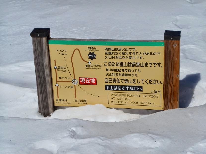
Continue round the back of the hut and you'll pass through a sort of gate with a ticket booth (closed in winter, of course) and the signpost in the photo above. Past here the trail turns into a dirt road, which will be snow-covered in winter.

Follow this road across a small bridge and round to the right, and continue up and along the trail through the forest for up to an hour until you come to the first of two torii gates.
The 一ノ鳥居 torii gate:

At this point the trail splits for a little while before both options meet up again at the second torii gate. The left fork crosses the river and heads up from there, and the right fork stays on the right bank up to the Fudoutaki waterfall (不動滝). I took the left trail, but either way it will only take you about 20 minutes to reach the junction just before the second torii.
Looking back at the meeting point of the two trails:

The 二ノ鳥居 torii gate:

Continue up the valley as the forest begins to open up, and you'll pass some very impressive rock formations on the right, as Asama finally peaks into view.

Continue upwards into an area called Kamoshika-daira (カモシカ平), and eventually you'll reach the Kazankan hut (火山館 Tel: 0267-22-1700). This hut was closed when I passed through, but it's a fantastic place to spend a few minutes admiring the rock formations below, and to stash any gear you don't need for your summit push, to collect on your way back down.
Kazankan hut:

The view from the hut's terrace:

Now you're ready for the final push to the summit. Ascend a short slope behind the hut, and continue up through the forest across a large gently rising plateau until you come across a (likely almost buried) signpost. This is the junction where a trail forks off to the left up to Mt Kurofu. That trail is buried in winter though, so it's not at all clear where it goes. You need to continue straight ahead for the summit though.

After a short time you'll leave the forest and things will open out beneath the Maekake crater rim, with stunning views all round. If you've been using snow shoes up to now, this is probably around the point where you'll take them off and put your crampons on. You'll need to make a rising traverse up a gradually steepening slope. Take a little care on this section as the trail will probably be banked out with icy snow, and the higher you go the further you'll slide if you slip.

Eventually you'll reach flat ground between the main crater and the Maekake crater, and you'll see a couple of iron emergency shelters. In theory these are to be used if you're unlucky enough to be there when an eruption occurs, but in winter they're generally choked full of snow.
Emergency shelters below the summit:


If you're planning to stick to the rules and forgo the main crater, continue past these shelters and ascend the snow slope on your right up the Maekake crater.

A short walk will see you at the hyakumeizan summit post of Mt Maekake (前掛山 2524m). The views from here are quite simply breath-taking!


The main crater just across from Maekake:

The Yatsugatake massif to the south:

The route you took to get here:

Now all you have to do is reverse the whole thing. Cheers!

If you're really lucky on your way down you'll encounter one of the Kamoshika that the forest is famous for. If so, try not to startle it, and enjoy the proximity to one of these magnificent creatures.

Overall:
What can I say? A fine mountain at any time of year, but particularly beautiful in winter. Take the usual precautions and gear you would for any winter climb above 2500m (ice axe, crampons, warm clothing, hot drinks and plenty of food, possibly snowshoes, avalanche gear etc.), and check the conditions and wind direction up there on the day before deciding whether to go for the main crater or not (I didn't). I'm certain you will not be disappointed!
Hi, thanks for the great article!
ReplyDeleteDo you happen to know where in Tokyo to buy gas canister for jetboil stove?
Hi there. Thanks for the comment, I'm glad you enjoyed it :)
DeleteYou can buy gas cannisters at any outdoor shop in Tokyo, no problems. You could try a Montbell store if there's one near you or, for example, either of these on the Yamanote Line:
1. Kamoshika Sports in Takadanobaba (JR Yamanote Line, or Tozai Line on the metro) http://www.kamoshika.co.jp/_src/sc240/yama20map.jpg
2. ICI Sports at Harajuku (JR Yamanote Line, or Chiyoda Line or Fukutoshin Line on the metro) http://ici-sports.com/shop/harajuku.html
Hope that helps...
Thanks much for the prompt reply!
DeleteHi Tony.
ReplyDeleteI've just returned from a summer holiday in Japan where I spent a bit of time of the time hiking and cycling. On the way back I decided I'd like to go a bit further on my next trip and scale a "real" mountain or two. The information that you've presented in your articles will be really helpful as I start planning my future adventures.
Hi Troy. Thanks for the nice comment. I'm glad to hear that you enjoyed your trip so much that you're planning a return! Also very happy to hear that the articles will be of use. All the best. Tony
DeleteMany thanks for the great write-up and photos. It's worth mentioning that Asama is also ski-able. A logical way to start is take a taxi up to Mine-no-Chaya (the pass on the east side of the main peak), then head towards the summit, as far as safety permits. Then either return to the pass, or ski the south flank, roughly following the summer route to the SSW of the main summit. But stay out of the bottom of the gully leading down to the Asama Sanso. A world of hurt (undergrowth, deep unski-able snow, avalanche risk) awaits therein ....
ReplyDeleteThanks for stopping by, PH.. Always a pleasure to hear from you. I think I remember reading your account of skiing the mountain. Thanks for the tips :)
DeleteThanks for the great article! Looking to climb it next week.. Are crampons really necessary, how steep is the last bit?
ReplyDeleteAlso, where could one obtain the best local weather forecast (for non Japanese speaker)?
thanks a lot
Hi Paul. Thanks for the feedback. Yes, crampons definitely necessary at this time of year. For weather, check the following web page in the days leading up to your hike, and consider cancelling if the wind speeds are showing anything above about 60kph.
Deletehttp://www.mountain-forecast.com/peaks/Asama-Yama/forecasts/2568
Also make sure you know what the current alert levels are on the mountain, and where hikers are officially permitted to go at the moment. You can of course ignore those warnings and restrictions if you want to, there are no police up there, but that's your lookout.
Have fun! Tony