Route
name: Nukubi-zawa (ヌクビ沢)
Mountain: Mt Makihata (巻機山,
1967m)
Sitting close to the Gunma/Niigata prefectural border, approximately midway between Mt Tanigawa (谷川岳) and Mt Echigo-Komagatake (越後駒ヶ岳), it’s no surprise that Mt Makihata gets buried under metres of snow every winter. By the end of the annual rainy season in early July, most of that snow is gone and the mountain’s verdant natural beauty and carpets of alpine flowers become a popular draw for hikers looking to tag another hyakumeizan (百名山) summit.
But not all the snow melts. With steep walls on either side shading it for much of the day, and the impressive Tengu (天狗岩) rock formation guarding its upper reaches, the Nukubi-zawa (ヌクビ沢) river course holds its snow almost year-round.

Whilst
not an alpine variation route, the Nukubi-zawa is a step-up from an ordinary
hiking trail. It may require some basic rope skills and equipment depending on
conditions, which could vary wildly from month to month and year to year. It
would be prudent not to try it during the rainy season, but from mid-July
onwards it’s game on. The later you leave it, the less snow and the
more dry rock you’re going to find. But for my money early summer is where it’s
at, when you can enjoy a cool breeze wafting down the snow fields while all
around the earth is baking.
Getting
there:
If
travelling from Tokyo by public transport, you need to take a shinkansen to Echigo-Yuzawa. From there, take a local
train to Muikamachi (六日町).
From there take a bus to the village of Shimizu
(清水),
and get off at the final destination. From the end of the bus route you’ll need
to walk up the zig zags of the road for about half an hour until you reach the
trailhead car park of Sakurazaka (桜坂).
If
travelling from Tokyo by car, take the Kanetsu Expressway all the way to
Niigata prefecture, through the tunnel that bisects Mt Tanigawa, and get off at
the Shiozawa (塩沢) exit.
Drive through scenic country roads to Shimizu, up to Sakurazaka, and park as
close to the trailhead as you can.
The
trail starts next to the large map board at the end of the top car park.
Description:
Take
the hiking trail from the car park, and very soon you’ll come to a junction
with a signpost. The trail on the right is the normal hiking trail, which
you’ll be descending from the summit. Take the left fork and walk along an
overgrown trail for 5-10 minutes until you find yourself walking up a stream.
Keep
going and you’ll soon reach another signed junction.

This
time you’d be better to take the trail on the right, which traverses the hillside
up above the river. The trail crosses
quite a few slopes that have collapsed, but as of 2015 it poses no problems.
After
about 45 minutes you’ll come out of the trees and drop into the Nukubi-zawa
itself, almost directly under the massive Tengu rock.

There
is another trail a few minutes further down the Nukubi-zawa, which heads up the
sawa on the left and then climbs onto the ridgeline above the Tengu rock. It’s
rarely taken though, and I can’t vouch for the condition it is in.

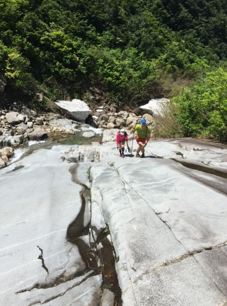
From
here onwards the trail alternates between rocky riverbed and snow fields. The rock is beautiful, and the snow is a
total joy to walk up. Pay attention to
those places where things transition from snow back onto rock, as the snow is
invariably thin and overhanging on its upper edge. In one or two places you
might need to scramble around the sides and drop back down into the riverbed
above, depending on what the conditions dictate.


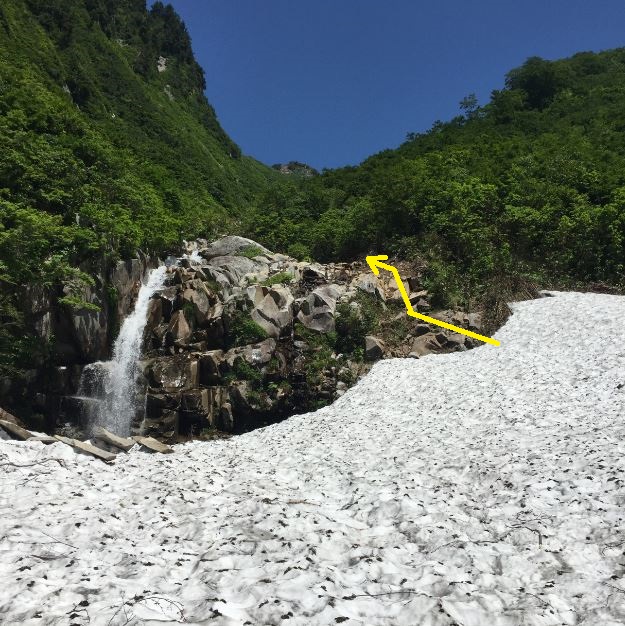


Eventually
the snow fields peter out, and a scramble up a stretch of loose rock (red paint
marks in places) brings you onto the final trail to the main ridgeline, just
below the 1931m summit of Mt Waremeki
(割引岳).
Mt Makihata lies another 20-30 minutes up the trail on the right.


Mt Waremeki summit marker:

For
some reason the summit marker of Makihata has been placed at a non-descript
trail junction, while the true high point is visible about 5-10 minutes further
on. The high point is surrounded by fields of delicate alpine flowers though,
so perhaps this was a conscious decision to protect the ecosystem from so many
pairs of hiking boots.
Mt Makihata summit marker:

The
panorama from the summit on a clear day is second to none, taking in all the
surrounding Niigata and Gunma hyakumeizan (Tanigawa,
Hotaka, Shibutsu, Echigo-Komagatake, Hiuchi) and even some of the Nikkō
giants (Oku-Shirane, Sukai).

From
the summit, head back to the main junction and take the trail down to the hut
on the shoulder, and then jog back down to the car park.

Overall:
A superb natural line up this beautiful mountain, and
without doubt the way to go if conditions are favourable. I advise giving it a
full day after heavy rains for the slopes to drain, to ensure that the river is
not too high, and be prepared to turn back if it’s not in condition.
Hey Tony, great and memorable course, but here in October I would have been delighted with snowfields, just to find some purchase on the cliffsides. You are correct though, that wet weather would make some of the traverses almost impossible. The scrambling and waterfall ascents were great fun, but the shit began when the trail ascended to traverse some of the falls. Seriously sketchy hillside trails, and would have much rather been roped! Well, anyway, an ascent in style. The other issue is rock fall in the upper part of the sawa. Got winged on my arm by one and had two crack into the hillside next to my head. Hopefully the cold weather keeps them a bit more stable! (Robert)
ReplyDelete