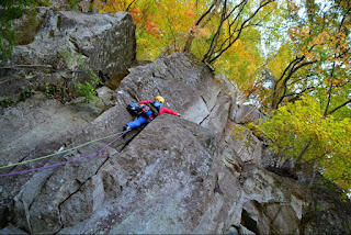
Route name: Saganryou (Left rock arête 左岩稜)
Mountain: Tachioka-yama (太刀岡山)
Map sheet:
26 [Yama-to-kougen-chizu (山と高原地図) series]
Length: 9 pitches (230m)
Time: 4 hours to the top of the last pitch
Grade: 5.9
FA: 篠原達郎、松原尚之 (2008)
Tachioka-yama is a minor peak of 1295m tucked in across the
valley behind Kayagatake (茅ヶ岳), its higher and more famous
neighbour to the north-west, known to many as the mountain on which Fukada Kyūya passed away in March 1971. The area around the
mountain is very beautiful on a sunny day, with picturesque farming villages
hanging on to lush green forested hillsides.
The main event is a dramatic triangular rock face on the
mountain’s western aspect with, as luck would have it, a spectacular
multi-pitch outing up its left arête that offers a variety of climbing styles
up impeccable rock and with sensational exposure at a comfortable climbing
grade. Running the whole gamut from trad cracks, friction slabs, run-out
face climbing and knife-edge ridges, this route comes highly recommended.
Getting there:
If
travelling by car from Tokyo you need to follow the Chuō Expressway out to
Yamanashi prefecture and take the exit for Futaba Service Area (双葉).
Find your way onto Route 6, then turn left onto Route 101. Follow this road for
about 9.5km until you come to a junction on the right with the Shosenkyo Line
road. Keep going straight on past this and the road changes into Route 27. A
further 2km through rural villages will bring you to the Tachioka-yama
trailhead car park on the left (太刀岡山登山口駐車場), with the rock face of Mt
Tachioka visible up on the right across the river.
The
approach to the start of the climb is short and easy. Walk up the road from the
car park for about 100m and you will come to a break in the barrier on the
right and a short gravel path down to the river. A makeshift bridge will get
you over the river.
Now
follow the trail as it zigzags up the hillside, and in about 5-10 minutes you
will arrive at a rock band. There are various routes up this rock band, but for
the ‘Saganryou’ route you need to skirt to the left along the foot of the
rock and you’ll soon reach the bottom of the first pitch.
Description:
Pitch
1: Climb the initial corner crack up to a narrow ledge, then climb the main
crack to a bolt belay. (20m 5.9)
Pitch
2: Climb the corner cracks to the big tree, then continue up beyond for another
10m to a belay. (25m 5.7)
Pitch
3: Climb the chimney cracks to gain the slabs above, and continue up on the arête.
(20m 5.8)
Pitch
4: Scramble up the arête to your right. (20m 5.5)
Pitch
5: There are two ways to start this pitch. (i) You can gain the arête on the right of the belay, and climb up featured but run-out
terrain to the scissor rocks. (ii) You can climb the crack on the left of the belay, followed by a knife-edge arête to gain the upper part of the first of the scissor rocks. Then cross the gap between them and continue up the arête.
(20m 5.8)
(i) Up the run-out arête:
(ii) Up the crack on the left:
The scissor rocks:
Pitch
6: Up the arête. (40m 5.6)
Pitch
7: Up the arête. (45m 5.6)
Pitch
8: Up the arête and along the famous knife-edge, to finish on the large terrace
at the top of the walk-off. (30m 5.6)
Pitch
9: Climb the face on your left by its weakest line, with trad pro in the first
half then bolts to the top of the pinnacle. (15m 5.8)
Descent:
From
the top of the pinnacle abseil back down to the terrace from a solid bolt
anchor.
The descent trail starts from the end of the terrace in the direction you originally came up from. Scramble around the corner on climber's right and you'll reach the main hiking trail after about 10 metres. Follow the trail
down past the Koyama rock face and on down to the river. Go through the metal
gate and cross a bridge, then walk back up the road to the car park. Descent takes round 20-30 minutes.
Overall:
This front-loaded route gets its main difficulties out of
the way in the first three pitches and then rewards you with a romp up a
magnificent arête on excellent friction rock. Bring a trad rack, and be prepared
for high quality climbing across a range of styles. A three-star route in
anybody’s book!
Available in print and e-book on Amazon.
Click on / tap the image to get your copy:


Hi Tony, do you think this route will be in condition at this time of year? Looking for an objective for next weekend. Thanks, Tom
ReplyDeleteSo sorry Tom, I literally didn't notice your comment sitting in the moderation section of my site until just now! This is obviously way overdue, but I'll reply here anyway as it might be useful for anyone with a similar question to you. You'd most likely find snow on Tachioka in February, and it would be way too cold for rock-climbing with bare hands. I've actually no idea whether anybody climbs this route as a winter climb but I doubt it. I don't think it would be good form to scratch up it in crampons. Tony
Delete