Route
Name: Kuro-sawa (黒沢)
Location: Matsuki-sawa valley (松木沢)
Time: 1 day
Grade: WI3+ / Overall grade 2 alpine route
Tucked in behind the Nikkō mountains,
near the former copper mining village of Ashio, the Matsuki-sawa valley is a
place of contrasts. This area was an important source of copper for the
Japanese government from the Meiji era right up to the 1970s, when operations
were ceased. It suffered many environmental disasters along the way, and the
landscape at the head of the valley is still deeply and visibly scarred by this
history.
Despite all this, once you enter
Matsuki-sawa you will likely be struck by the beauty and ambience of the place,
with its steep craggy cliffs and alpine feel. It’s an impressive place, and made
even more beautiful by the absence of the hordes of hikers that are to be found
in Japan’s more well-known mountainous areas. From hiking to sawanobori, multi-pitch
rock-climbing to alpine ice-climbing, the area is an adventure playground and a
real reward to those who make the effort to find it.
Getting there:
If travelling from Tokyo (東京) by car, take the Tōhoku Expressway as
far as Utsunomiya (宇都宮), then change onto the Nikko-Utsunomiya
road until it turns into Route 120. Turn left onto Route 122 and stay on this until
it meets Route 250, then turn right onto Route 250. Keep going straight on up
the Ashio (足尾) valley on this road until you reach
its end at the small car park above the Akagane Water Park (銅親水公園).
Description:
From the car park, you need to walk a
little further up the road you drove in on, go past the barrier blocking the
road, and cross the bridge to get over the river on the left. Walk along the
road as it doubles back round to the left and then swings northwest again
towards the entrance to Matsuki-sawa (松木沢).
Once into Matsuki-sawa you need to keep
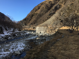
walking for about 1.5 hours to reach the entrance to Kuro-sawa (黒沢). Initially you will be on a good dirt road
until you reach the Matsuki village.
From there onwards the road becomes less maintained,
and in several places has been completely covered in boulders from landslides
and rockfall from the mountainside on your right. On the left side of the
valley large rock faces begin to appear, and the summit ridge of Nakakura-yama
(中倉山) can be seen high above. This ridgeline
eventually leads over Koushin-san (庚申山) to Nokogiri-yama
(鋸山) on the main ridge before the summit of
Sukai-san (皇海山), and is a dramatic and high-quality
hike in its own right.
Eventually you will arrive at a large
concrete dam next to the Kuro-sawa valley coming down the mountainside on your
left. You will be able to see the first few icefalls from here. Scramble down
to the river and cross it by whatever means available, then hike up the
approach trail on the other side.
The first icefall (F1) does not always
form very well, and is rather gentle anyway, so this can be bypassed by
sticking to the trail up on the right.
F1:
This trail will soon enter the sawa, and
then several hundred metres of hiking up the frozen river will bring you to the
main icefalls.
F2 is approximately 30m high, and can be
tackled straight up the middle or close to the rocks on its left side. There is
a bolt anchor at the top of it on the right. Many thanks to Mathieu for
replacing the previous rusty old anchors with these solid bolts.
F2:
The F3 icefall is located directly above
F2, and is the tallest fall along this route. There are plenty of ways this can
be tackled. Most parties climb it in two pitches, an initial 40m pitch leading
to an old bolt anchor on the rock above the centre of the icefall, then a
shorter 10m pitch up the narrower section to the top, with a solid bolt anchor
on the right. With 60m ropes you could climb it in a single direct pitch if you
like.
F3:
After this you need to hike quite steeply
for about 10 minutes up the sawa to reach F4, a 30m icefall in a sort of gorge-like
constriction. There is a tree anchor just back from the top of this one.
F4:
To descend, just rappel the icefalls on
good in-situ anchors and hike back down and out.
Overall:
An excellent route in a beautiful location,
with good quality icefalls of a satisfying length and a moderate difficulty. Recommended
even as a one-day hit, it could also be combined with one of the neighbouring sawa
routes to provide a very nice weekend of ice-climbing. February is the optimal
month to find good ice conditions in here.


No comments:
Post a Comment