Route Name: Nan-ryō Flank (南稜フランケ)
Mountain: Tanigawadake (谷川岳)
Map sheet:
16 [Yama-to-kougen-chizu (山と高原地図) series]
Length: 6 pitches (+
200m simul-climbing to the summit)
Time: 4-6 hours to
the top of the last pitch
Grade: V+ crux pitch
/ Overall grade 4+ alpine route
FA: 横尾康一、八島晃、加藤滝男、星川政範 (1964.7.23)

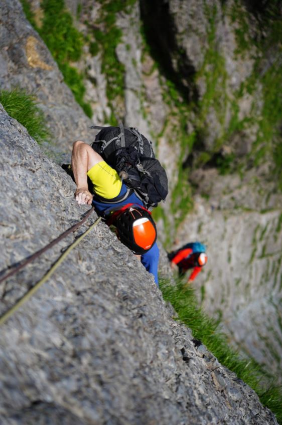
The Nan-ryō Flank route takes a line up the steep face on
the side of the Nan-ryō (South arête), at the far edge of the Eboshi-sawa
Okuheki (烏帽子沢奥壁) in the stunning Ichinokura-sawa (一ノ倉沢) valley on
Mt Tanigawa.
It is one of the more serious routes in the area,
characterised by consistently steep and involved climbing, long runouts between
pieces of old in-situ protection, and consequently notable route-finding
challenges. Every single pitch is grade V and the crux is V+. At the time of
the first ascent in July of 1964 this was the hardest pitch grade in Japan,
although nowadays there are plenty of more technical routes around.
But the Nan-ryō Flank retains its seriousness and alpine
character, and should not be undertaken lightly. In the Japanese guidebook
Kikuchi-san finishes his entry for this route by saying “Please approach it
with sufficient confidence and experience as a route where a fall is absolutely
unacceptable”. I do not disagree.
Getting there:
From
Tokyo take the Takasaki Line to Takasaki (高崎, about 1.5hrs).
Change for the Jōetsu Line to Minakami (水上, about 45mins), then take a local for
2 stops to Doai (土合). From the underground platform at Doai
station, climb a 489-step staircase from hell to reach ground level. Exit the
station and join the main road, turning right and walking under a railway
bridge. Follow this road for about 20 minutes up to the Visitors Centre.
Description:
Walk up the road from the Visitors Centre for about half an hour until you get to the entrance to Ichinokura-sawa (一ノ倉沢). Head up the sawa until you reach the foot of Tail ridge, and ascend this all the way to the top, at the foot of the Tsuitate-iwa (衝立岩) rock face.

From here make an exposed rising traverse to your left across the steep
slabs in the direction of the Nan-ryō terrace. Just before the final scramble
up to the terrace you will find the bottom anchor for this route.

Approximate
pitch descriptions for the route are as follows:
Pitch
1: Climb steeply up past an in-situ piton at around 6m, then continue up and
around the edge. Take the line of least resistance as it weaves up the face to
a bolt anchor. (30m V)

Pitch
2: Make initial steep moves over a bulge from the anchor, then continue up runout
terrain bearing slightly left to belay beneath the large overhang above. (40m
V)


Pitch
3: Traverse to the right under the overhang, then climb straight up the face
making delicate moves on thin edges. (40m V+)

Pitch
4: Traverse the band left from the anchor and carefully climb the initial
slabby face with no available protection. From the terrace above traverse
delicately left and climb the rock rib to the anchor. (40m V)

Pitch
5: Climb the face above with an in-situ RCC bolt, then make an exposed traverse
leftwards through grass and bushes to reach the horse’s back upper section of
the Nan-ryō route. (40m V)

Pitch
6: Climb the corner crack above, then continue up the final face to the anchor
at the top of the Nan-ryō. (40m
V)

(Note:
If you continue straight up on pitch 5 instead of making the traversing exit
from the face you will end up on the old YCC route, and be required to make a more
difficult exit from the face from an extremely exposed anchor stance directly
below the roof at the top. Avoid this unless you want to amplify your
adrenaline levels significantly!)
Descent:
Once
you get to the top of the Nan-ryō, you can traverse across to the top of the
line of rappels which is the standard rappel descent. It will take you about
five rappels on double ropes to reach the terrace at the start of the Nan-ryō.
From here you can either unrope and downclimb or do one more rappel to easier
ground.
Now
you just need to traverse back across to the top of Tail ridge and descend back
out of Ichinokura-sawa to the road.
Alternatively,
if you wish to extend the day and take in the summit ridge too, you could
continue up to the top of Ichinokura-dake (一ノ倉岳). This
involves about 2 hours of fairly steep and exposed scrambling and bushwhacking,
and I would recommend keeping a rope on and simul-climbing together, with the
leader placing running protection as you go.


From
the summit of Ichinokura-dake, traverse the main ridgeline over the summits of
Okinomimi and Tomanomimi, and either descend the Nishikuro ridge (西黒尾根)
or, if you have time before the last cable car of the day, head down to
Tenjindaira (天神平).

Overall:
A magnificent visionary achievement on the part of the first
ascensionists, which remains undiminished in character to this day. Heed
Kikuchi-san’s warning about this route though, and only try it if you really do
feel confident about it, as it will be unforgiving of any mistakes. Climb
confidently as if you are free-soloing, and be really careful with your
route-finding.
*** NEWS ***
Remember to order your copy of Volume 2 of the "10
Classic Alpine Climbs of Japan" series from Amazon today.

No comments:
Post a Comment