Route
Name: South ridge
(Nanryou 南稜)
Mountain: Amidadake (2805m 阿弥陀岳)
Map
sheet: 33 [Yama-to-kougen-chizu (山と高原地図)
series]
Time: 2 days round trip
Grade: III / Overall Grade 1 alpine
route

Getting
there:
If
travelling by train from Tokyo (東京)
or Shinjuku (新宿),
take a Chuō Line (中央線) train
out to Chino (茅野) station. Ideally you want to be on the first Super
Azusa limited express train in the morning. There is no bus to the trailhead for this climb, so you will need to
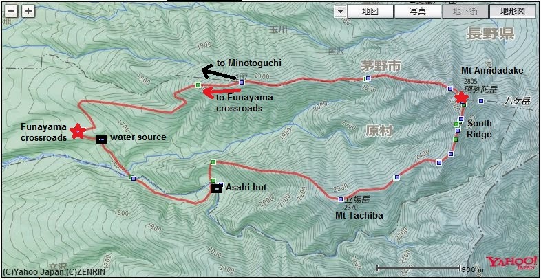
take a taxi to Funayama crossroads (船山十字路). After climbing the route you will need to descend
to Minotoguchi (美濃戸口)
for a bus back to Chino.
If
travelling by car, there are plenty of parking spaces at Funayama crossroads,
and you will be able to re-join your car at the end by following the route
described below.
Description:
* DAY
ONE
Take
the right fork at Funayama crossroads.


Walk
up the road for about 10 minutes until you reach a water source (marked 阿弥陀聖水
on the map). A short way past
this water source there will be a road branching off to the right down the hill
to the Tachiba River campsite. Ignore this, and continue along the road
heading up on the left. After another 10
minutes you will come to a gate, and the end of the tarmac road. Go through this gate, cross the Hirogawara stream (広河原沢),
and continue up an unpaved track for about another 40 minutes, until you reach
the old Asahi hut (旭小屋).


Go
right up to the hut, and then follow a single-track trail off to the left,
cross a small stream, and then continue up the trail towards the
ridgeline. The trail is quite clear and
easy to spot, but there are plenty of pieces of red tape on tree branches and
red paint marks on rocks as well.


Once
you hit the ridgeline, turn right and follow the trail up the crest of the
ridge. Amidadake is a holy Buddhist
mountain, as the name ‘Amida’ would suggest, and there are relics and trail
markers all along its various ridges.
Keep
walking up for about another hour or more until you reach the tree-covered
summit of Mt Tachiba (2370m 立場山).
")
Mt Tachiba summit marker:
")
From
here onwards you should be looking out for a good flat camping spot in the
snow. About half an hour beyond Mt
Tachiba there is an open traverse with a landslide off to the right side, from
where you will catch your first full sighting of the South ridge. We camped just before this traverse, and it
was an excellent spot with room for several tents.


* DAY
TWO
Cross
the landslide traverse and continue up the ridge on the other side. After about half an hour of ascending you
will reach the junction with the South ridge proper on your left.


There
are four pinnacles along the ridge, which you will need to get over or around
to reach the summit.


P1
and P2 are both straightforward, involving just steep walking and easy
scrambling. The views on all sides are
fantastic, from Gongendake (権現岳) to the south all the way to
Tateshina (蓼科山) at the northern end of the Yatsugatake (八ヶ岳)
massif.

P1:

P2:

P3
is the crux of the route and for most people will be the point where they get
the rope out. A short way along from P2
you will reach the start of the P3 traverse.


Walk
along a comfortable ledge of about 20m, and then continue round the corner and
down to the bolt belay at the start of the P3 gully. From the rock step at the start of the gully
to the top of P3 is about two rope lengths, with a solid bolt belay to anchor
from in the gully.
Climb
an interesting and exposed little rock step to gain access to the gully, with
an in-situ ringbolt at the top of it. Now climb the gully on ice and snow, clipping whatever in-situ
protection you can find. There are
several ringbolts along the way. If you
have a 60m rope, you will be able to get all the way to a solid bolt at a
narrow ledge at the top of the gully. If
not, belay at one of the ringbolts lower down.


One
more easy pitch will get you to the top of P3. From here you will see P4 a short distance along the ridge.


To
get round P4 you will need to traverse a very narrow ledge, with some exposure
on climber’s left, but it is not difficult. After that, climb a short rock step and then climb about 40m of
straight-forward mixed ground to the crest of the ridge.


From
here it is just a short climb up to the summit.


Descent:
To
get down from the summit you could take the trail to the east, which heads in
the direction of Mt Akadake (2899m 赤岳)
for a long walk back to the Minotoguchi trailhead, but the round trip I’m
describing takes the trail to the west off the summit. A short walk along a narrow ridge brings you
to some rocks, with a ladder and chains. Climb over these rocks and down the other side to a signpost.


From
here you can see your descent down the Okoya ridge (御小屋尾根) stretching out below, and the top section
has a fixed rope in place down the first 100m.

After
1h20mins of map-time you will reach a sign indicating a water point off to the
left (不動清水) at about 2206m. Keep going down the ridge and after another 1h10mins of map-time you
will arrive at a fork in the trail just
after the 2137m summit of Mt Okoya (御小屋山).

The
right fork goes to Minotoguchi bus stop, and the left fork will take you back
to Funayama crossroads. The car park at
Funayama crossroads is another 1h20mins of map-time down the ridge.
Overall:
The
South ridge is an aesthetic and highly-enjoyable outing, never overly difficult
but always interesting and involving a mix of terrains and skills. This is probably the classic outing on
Amidadake, and is a ‘must’ for any Yatsugatake winter climber.
Hi Tony,
ReplyDeleteNice blog.
Any way to contact you for more info about the various routes here?
Thanks,
Peter