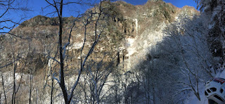
Area name: Ōyafudō (大谷不動)
Location: Nagano
prefecture, behind Mt Azumaya (四阿山)
Grades: WI4 – WI6
*** Note: Since the winter of 2017-18 Ōyafudō has been closed to climbers until further notice due to access issues with the landowners. ***
Ōyafudō is without doubt one of the most spectacular areas for steep ice-climbing on Honshu island. Access is relatively simple, and the ambience is really something… With vertical ice pillars up to and over 50m high, and several multi-pitch icefalls, this is a serious place and demands confidence. To really enjoy climbing here you’ll need at least one person in your group who can lead WI4+ upwards.
Ōyafudō is without doubt one of the most spectacular areas for steep ice-climbing on Honshu island. Access is relatively simple, and the ambience is really something… With vertical ice pillars up to and over 50m high, and several multi-pitch icefalls, this is a serious place and demands confidence. To really enjoy climbing here you’ll need at least one person in your group who can lead WI4+ upwards.
You’ll want to climb on 60m double ropes because
pitches tend to be long, and getting down from the anchors will involve rappels
of up to 60m. The icefalls tend to have in-situ anchors at the tops on trees.
It pays to inspect the ropes/slings that are in place and consider using your
own if they don’t look perfect. If you choose to break any icefalls down into
two pitches, you’ll need to set up your own anchor on ice screws.
Getting there:
To get there from Tokyo you’ll almost certainly need
to drive, as there is really no decent public transport connection to get
there. It takes about three and a half hours from central Tokyo. Take the Kanetsu
Expressway towards Gunma, and then fork left onto the Joshinetsu Expressway
soon after the Kamisato (上里) service area. Come off the highway at Ueda (上田) onto Route 144. Turn left onto Route 406, continue
through Sugadaira (菅平), and head for the Minenohara ski resort (峰の原のスキー場). Leave your car in the resort’s car park.
After about 15 minutes you’ll reach a col, and you
need to continue down the other side along a path.
The trail will zigzag down for about 15 minutes until
you come out on a snow-covered rindou
(mountain road) with a metal bell by the roadside.
Turn right and follow the road as it contours along
for about 20 minutes. Eventually the trail will ascend up through the forest as
the icefalls come into view across the valley. You’ll soon come to a fork, with
the right trail leading to the Fudōmae
(不動前の氷瀑) icefall,
and the left trail leading up to the hut (unmanned).
You can leave your snowshoes and any unnecessary gear
at the hut, it should be quite safe in Japan.
THE ICEFALLS:
(Map adapted from the out-of-print Japanese guidebook
“アイスクライミング”)
1. Fudōmae
falls (不動前の氷瀑) - 50m
WI4 (Japanese grade V+)
2. Left wall Saganpeki area (左岩壁)
* Left route (左ルート), 2 pitches, F1 50m and F2 40m (Japanese grade VI)
* Central route (中央ルート), 2 pitches, F1 45m and F2 40m (Japanese grade VI-)
* Right route (右ルート), 2 pitches, F1 40m and F2 35m WI5+ (Japanese grade
VI-)
3. Honryū falls (本流)
* Ichinotaki (一の滝), 7m WI3+
* Ninotaki (二の滝), 55m WI4+ (Japanese grade V+)
* Sannotaki (三の滝), 30m WI4
4. Honryū right
flank falls (右側壁の氷瀑) –
50m WI5 (Japanese grade V+ to VI-)


No comments:
Post a Comment