Route
Name: Nishikuro ridge (西黒尾根)
Mountain:
Tanigawa-dake (谷川岳)
Map sheet:
16 [Yama-to-kougen-chizu (山と高原地図) series]
Time:
3-4 hours to the top

Mt Tanigawa (谷川岳) sits along the prefectural border between Gunma and
Niigata, and as the moist winter air from the Sea of Japan meets its summit
ridge it lets loose colossal amounts of snow. The cornice that forms along that
summit ridge can be the size of a house, and the area is renowned for
avalanches when temperatures rise towards zero.
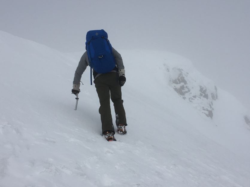
Tanigawa is home to some of the most demanding winter
alpine climbs in Japan, many of which require serious skills, judgement and
courage. For those looking to step up from the easier hiking trail at the
southern end of the ridgeline, the Nishikuro ridge (西黒尾根) is an excellent way to reach the summit and sample
the way conditions can be on Tanigawa, but with more moderate difficulty. In
good consolidated snow it is quite straight-forward, dramatic at times but with
little technical difficulty. In the darkest depths of winter though, you should
be prepared for deep untracked snow and a level of adventure that belies its
modest technicality.
Getting
there:
From Tokyo take the
Takasaki Line to Takasaki (高崎, about 1.5hrs). Change for the Jōetsu Line to
Minakami (水上, about 45mins), then
take a local for 2 stops to Doai (土合). From the
underground platform at Doai station, climb a 489-step staircase from hell to
reach ground level.

Exit the station and join the main road, turning right and
walking under a railway bridge. Follow this road for about 20 minutes up to the
Visitors Centre.
Description:
From
the Visitors Centre you need to walk up the road to the mountain rescue hut and
then continue on for two more switchbacks, and you will soon reach the
trailhead for the Nishikuro ridge.

The
first 10-15 minutes past the trailhead take you up a fairly steep forested
trail until you crest the ridge below a large electricity pylon. Continue past this
pylon up the tree-covered ridgeline for several hundred metres. Depending on
the year or the stage of winter you’re hiking in, this section may well require
snowshoes to make any progress at all. Eventually you’ll come to a short
descent down to a level section with a striking cornice on climber’s left.

Continue
upwards as the ridge begins to narrow and the trees start to thin out, and you’ll
come to a sort of saddle at treeline. From here on you’re on the upper ridge,
and things will become more interesting and more exposed.


First
you need to traverse a few pinnacles, and a couple of minor rock steps with
in-situ chains provide some added interest on this section. The ridge gets quite
narrow in places, with mounting exposure on both sides and a large cornice on your
left.
Looking back at the corniced ridgeline:

Beyond those pinnacles things broaden a little more, but the angle of
the slope increases as you begin the ascent of a long snow slope past some
rocks. The trace will most likely bypass these rocks to climber’s right, but taking
them directly provides an enjoyable little scramble.

Now
you’re really getting into the final steep upper section of the Nishikuro ridge
so just keep going upwards, but once again, be very aware of the cornice on
your left.

Eventually things will begin to level off for a short while, and then
you’ll pop out onto the main summit ridge in front of a large cairn with
signposts, just 50m horizontally from the hut. This cairn marks a trail
junction, with the left route heading down the more gentle ordinary hiking
trail to the Tenjindaira (天神平) ski piste, and the
right route heading up to the summit.

Turn
right and continue upwards, and you’ll soon arrive at the 1963m summit of
Tomanomimi (トマの耳). This is as far as most hikers go, and on a good day
the views are pretty special.
Tomanomimi:

If
you want to reach the true 1977m highpoint of Mt Tanigawa you’ll need to
continue along the ridge for another 15 minutes to the top of Okinomimi (オキの耳).
It really is worth the extra effort to get there, and the view back along the
ridge to Tomanomimi is the classic money shot for winter hikers on Tanigawa.
Okinomimi:

Looking across to Ichinokura-dake:


Descent:
There
are three options for getting down, as follows:
(i)
Continue along the ridge to the summit of Ichinokura-dake (一ノ倉岳), and
then swing towards the west to Shigekura-dake (茂倉岳)
and hike all the way down to Tsuchitaru (土樽) station. Be aware that
very few people do this, so beyond Ichinokura-dake you’ll almost certainly be
breaking trail through deep snow.
(ii)
Head back over Tomanomimi to the sign-posted trail junction near the hut, and
continue straight on down the ordinary path to Tenjindaira (天神平),
and take the ski gondola back down to the Visitors Centre.
(iii)
Descend the way you came up, straight back down the Nishikuro ridge. If your
aim is to train for winter mountaineering then this is the recommended descent,
as it will require you to negotiate your way down some steep and exposed snow
slopes in the upper half, and will put an important 1000m of descent into your
quads.
Overall:
An
excellent winter hike to one of the most fabled and exciting summits in the
area, elegantly bridging the difficulty gap between the easier hiking trail
from the ski gondola and the more serious winter alpine routes in
Ichinokura-sawa and Yuno-sawa to the north. I’d recommend carrying snowshoes,
even if you end up not using them. Treat this route as an opportunity to train
for harder things, as well as an excellent winter ridge hike in its own right.
No comments:
Post a Comment