Route Name: Shinozawa Shichijō-baku (篠沢七丈瀑)
Mountain: Kaikomagatake (2967m, 甲斐駒ケ岳)
Map
sheet: 41 [Yama-to-kougen-chizu (山と高原地図)
series]
Time: 1 day
Grade: WI4 / Overall grade 4 alpine route
FA: 小森康行、服部清次、東吉男(JCCJ)(1963.1.12-1.15)

Mt
Kaikoma is the venue for a number of big and serious alpine climbs in all
seasons. It sits like a fortress at the north-eastern end of the South Alps, on
the cusp of civilisation and yet simultaneously large and remote, with no short
or simple way to its summit. Even its ordinary hiking trail up the Kuroto
ridge is long and tiring, particularly with a backpack full of winter camping
and climbing gear, and this requisite effort and commitment is what makes any
climb on Kaikoma special and noteworthy.
The
famed Oren-dani
ice routes are located on the northern side of the Kuroto ridge. But over on
the opposite southern side lies a gully named Shinozawa, home to the
magnificent 3-pitch Shichijō-baku icefall. Marginally steeper than the Ōtaki of
the Oren-dani left fork, and with a slightly higher Japanese technical grade, Shichijō-baku
can be climbed in a single long day up and down from the car park for those
wishing to push the pain levels.
It generally forms in late December, and will stay in condition until early March. Depending on conditions, getting off from the top can involve simul-climbing and placing running protection across some steep and exposed terrain, giving the day a full alpine flavour.

Getting
there:
If travelling by car from Tokyo (東京), take the Chuō Expressway to Sutama (須玉) and then exit onto route 141. A combination of local roads will bring you within about half an hour to the Hakushukankōjiro camping ground (白洲観光尾白キャンプ場). The car park here is the end of the road and the access point for the Kuroto ridge of Mt Kaikoma and all climbing routes on the east side of the mountain.

Description:
THE APPROACH
From the car park, walk past the barrier and continue
along the rough road for about 5-10 minutes until you reach the Chiku-Komagatake shrine (竹宇駒ケ岳神社), an ancient holy site for shugendō religious practice. From the shrine, cross the suspension
bridge over the river and follow the path upwards through the initial zigzags.
After about 30mins the path will veer to the left and
contour up and round onto the crest of the ridge. Keep going, and after about 2
hours of map time you will reach a junction where your trail is joined by
another approach trail that came up from Yokote-Komagatake
shrine. You are now on the Kuroto ridge proper. Keep following the path up
through the forest, with red paint markers on the trees to show you the right
way.
After about 1.5 hours the ridge will begin to narrow until you reach an airy knife-edge section with chains. Cross this with care, and after another 15-20 minutes you will reach a small shrine at 2049m. From here on you will begin to encounter ladders fixed on the steep sections.

Keep going for another hour or so and the trail will
descend for about 100m to a col. This is the 5th station on the ridge. In the
past there was an emergency hut here, the Gogome-goya (五合目小屋), but this hut no longer exists.
Continue across this col and up a series of steep ladders and chains to the top of the next section of the ridgeline. After about 25 minutes you will come to a short horizontal bridge. This is the entry point for the descent to access Shinozawa.

From here climb down steep snow slopes for several hundred metres to the entrance to Shinozawa, where the Shichijō-baku icefall comes into view on your right.


THE CLIMB
The main icefall is around 80m in height, and is generally climbed in 3 pitches. The first pitch is relatively moderate, around WI3, ending at the start of the more vertical upper middle section.


The middle section is the crux, and is both steep and sustained WI4-5.
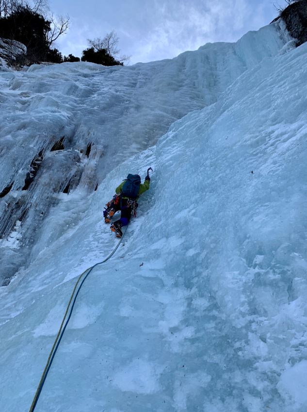


From the top of the main icefall a more moderate third pitch takes you up at around WI3 to belay on some trees off the right edge of the gully.


If conditions allow, it is sometimes possible to
continue up the easier frozen slabs above, followed by a long snow slope to top
out on the Kuroto ridge around the level of the 7th station hut. But
the more usual descent is made either by rappelling the icefall and reversing
your approach, or traversing off across an angled band on climber’s right.
This is very exposed and steep in banked out conditions, and protection can be placed on occasional trees. Two 50m rope-lengths will bring you to the point where the angle eases and the rope can be removed. From there simply regain your descent tracks and climb back out to the bridge on the Kuroto ridge, and begin the long 3–4-hour slog back down to the car park.

Overall:
A magnificent piece of frozen architecture, austere
and demanding. The long approach and descent turn this into a fantastically
satisfying day combining the skill sets and techniques of ice-climbing and
alpinism. Bring 10-12 ice screws and quickdraws, and a selection of slings.
*** NEWS ***
Don't forget to order your copy of Volume 2 of the "10 Classic Alpine Climbs of Japan" series from Amazon today.

No comments:
Post a Comment