Route Name: Yatsumine main ridge (八ツ峰主稜)
Mountain: Tsurugidake (剣岳 2999m)
Length: Approx. 1000m
Time: 8-10 hours to the summit
Grade: III-III+ / Overall Grade 1 alpine route
FA: 02 Aug 1923 Kazuo Okabe, Sosaku Saeki

If
there is a more beautiful ridge in the North Alps of Japan than the Yatsumine
on Mt Tsurugi, then I am yet to find it. Classed as one of the three great
ridges of Japan (along with the North
ridge of Mt Maehotaka and the Kitakama
ridge of Mt Yari), it is a highly sought-after prize, and a big day out.
Running roughly parallel to the Genjiro
ridge (源次郎尾根), it
forms a crenelated wall up the northern edge of the Choujiro-dani (長次郎谷) valley. As the name suggests, there are eight major
pinnacles to be overcome along the way, as well as more minor ups and downs.
Each is equipped with an abseil anchor, although in summer conditions some can
be downclimbed.
The ridge can be climbed in its
entirety from the ‘1-2 col’, the gap between the first and second pinnacles.
But this requires clear access up a gully, and is not safe in early summer
conditions, when the lower reaches are still choked with old and
heavily-crevassed snow. Most people access the ridge midway from the 5-6 col
and climb the upper half (上半).
My advice, if you’ll permit me…
Wait for good weather, clear views in all directions, and savour every minute
of it!
Getting there:
Access
to Tsurugidake requires getting up to
Murodō (室堂) on
the large plateau below the summit of Tateyama
(立山) in the North Alps. If
travelling from Tokyo on public transport there are a couple of ways you can do
this, none of them easy, but the quickest and cheapest way is as follows. Take
a Chuō Line limited express Super Azusa from Shinjuku station to Matsumoto (松本),
then change onto the Ōito Line (大糸線)
for a local train to Shinano-Ōmachi (信濃大町).
From there you’ll need to take a bus to Ōgisawa (扇沢, 45mins, ¥1330).
At Ōgisawa, queue up at the ticket office and buy a return ticket for the Tateyama
Kurobe Alpine Route (立山黒部アルペンルート, timetables here). This convoluted but
impressive series of stages will take you through a trolley bus up to the
famous Kurobe Dam (黒部ダム),
followed by a funicular railway, a ropeway and then a final trolley bus through
Mt Tateyama to Murodō.
From
Murodō head out of the top station and find the most direct way through the
maze of trails through Jigokudani, down to the campsite at the valley floor,
and then up the trail on the other side to the Tsurugigozen (剣御前) hut up on the col. From there a
short walk will bring you down to the Tsurugi-sawa
camp ground (剣沢キャンプ場).

The
approach:
After an early headtorch start, follow the hiking
trail down Tsurugi-sawa. At the Tsurugi-sawa hut (剣沢小屋) the trail forks, with the left trail heading across
to the normal ‘Bessan ridge’ hiking trail up Mt Tsurugi. You need to take the
right trail down into the lower reaches of Tsurugi-sawa, and things begin to
steepen a little at this point. The trail is not all that clear in the dark,
but there are occasional paint marks on rocks to keep things honest.

At some point you’ll reach the top of the snowpack
that sits year-round in Tsurugi-sawa. The later you are in the summer, the more
you’ll need to pay attention to the condition of the snowpack. If it looks
solid, the easiest thing is to put on a pair of crampons and just walk straight
down it. Otherwise, the actual hiking trail clings to the right bank above the
snowpack.
After an hour or so you’ll come to the entrance to the
Heizotani (平蔵谷) valley on your
left, dropping precipitously from the shoulder of the mountain. This also
contains year-round snow, and in good conditions is a popular variation route
to reach the summit. The enormous foot of the Genjiro ridge will have been
silhouetted in front of you for some time now. Continue down past it for
another 20 minutes, and you’ll reach the Choujiro-dani deai (長次郎谷出合), the entrance to the Choujiro-dani and the access
for the Yatsumine.
Enter Choujiro-dani and start ascending the snowfield.
At first the valley is quite narrow, with steep rock walls hemming you in on
both sides. Pay attention to the possibility of rockfall here.

After around half an hour you will pass the access to
the gully on climber’s right that leads up to the 1-2 col. If conditions in
there look good, go for it. Otherwise, continue up the snowfield for another
hour or so.
As you gain altitude and the valley opens up, you will
see the Genjiro ridge high up on your left, and the battlements of the
Yatsumine on your right. Up ahead sits a large plateau of rock named
Kuma-no-iwa, around two thirds of the way up the valley, and with space for
several tents on top.


The 5-6 col is up on your right, accessed by a fairly
steep slope. You will recognise it by its position to the right of the line of
rock buttresses that make up the south side of the roppou-mine (VI峰), the number
6 pinnacle.
Given letters of the alphabet
right to left from A-face to E-face, these buttresses are home to a host of
popular multipitch rock climbs of all grades. Many climbers choose to access
the ridge by first climbing one of these routes, but the easiest option is to
go directly to the 5-6 col and begin your climb from there.
Let’s pause the Yatsumine
here for a moment though, and climb one of these face routes.
A-face “Uozuko route” (Aフェース魚津高ルート)
Scramble up to the foot of
the A-face, and gear up on the ledge at the bottom of the groove that forms the
first pitch. Approximate pitch descriptions are as follows:
Pitch 1: Climb the groove
past an initial bulge up to a small corner overhang. Overcome this on the right
to access a crack system, then continue up leftwards to reach the belay ledge
on the arête. (40m IV)

Pitch 2: Climb steeply up
the arête in a magnificent airy position on largely positive holds, to reach an
old piton anchor. (40m III)

Pitch 3: Continue up the arête
until the angle eases, then scramble up the line of least resistance to the top
of the A-face. (40m II)

The A-face stands separate
from the main ridge of the VI峰, so you’ll need to descend most
of the way down to the 5-6 col. Make an exposed scramble down about 15m, then
rappel off an anchor in the haimatsu (dwarf pine) to reach a system of ledges above the col.
From here you can scramble across to reach the normal ascent route on the
Yatsumine.
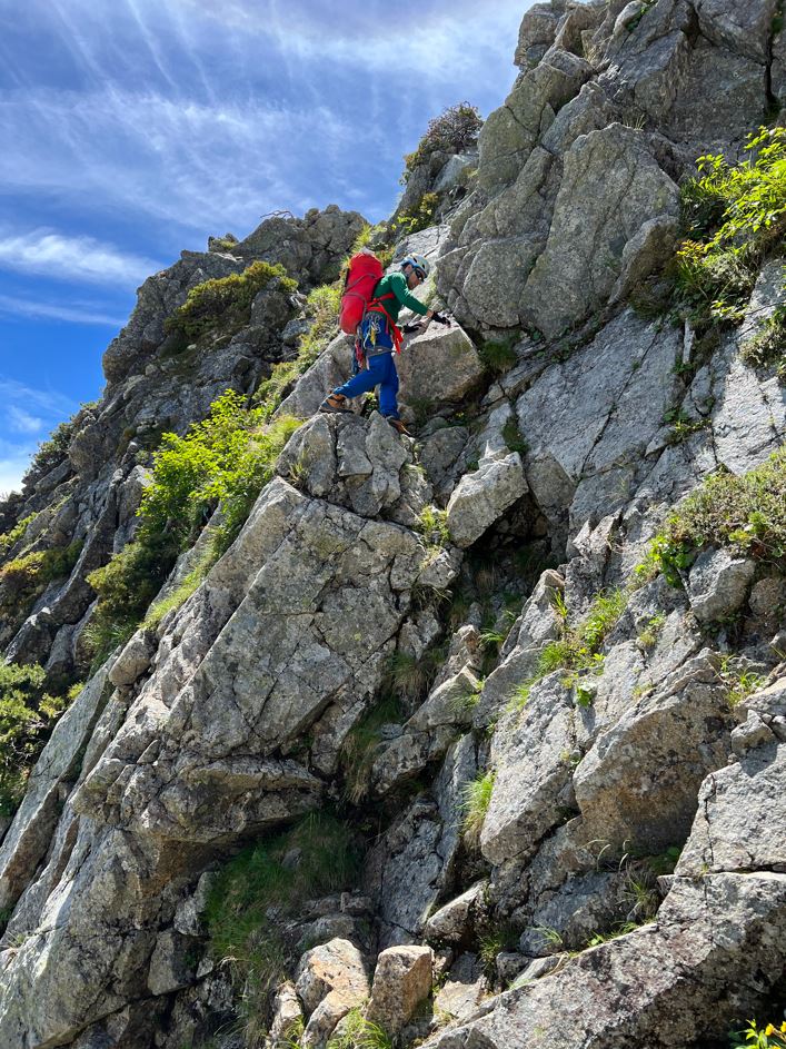
Yatsumine
upper half description:
As
always, I don’t want to describe the main ridge too closely and detract from
your own sense of enjoyment and discovery.
From
the col, just find the line that looks the most travelled, and start the climb up
the VI峰. The first hundred metres or so are quite steep and
exposed, but well featured. There are in-situ pitons and belay anchors if you
need them, but there’s nothing more difficult than grade II-III.


Eventually, the angle begins
to ease and it should take around half an hour of scrambling to reach the top.
There is an abseil anchor in place, but this one is reasonably featured and can
be downclimbed.

Next, cross a few minor pinnacles
on the right side of the ridge, then begin the steep climb up the VII峰. The climbing
always looks improbable, but turns out to be well-featured and engaging.

The ridge crest is a very airy
place here, and after an initial abseil from the VII峰, a scramble
brings you to another abseil anchor.
This one takes you into a
notch, with a short climb up the other side, then a further 15m abseil into a
tight col below the VIII峰.
The climb up the VIII峰 requires first
traversing along a narrow ledge with good handholds, but leaning back over the
void. It looks and feels quite dramatic. A chimney leads up on climber’s right,
and after an exposed 50m you will arrive at the summit of VIII峰. Many parties
opt to rope up for this section.

Make a 50m abseil off the
back of VIII峰 to the col below the final
climb up to the Yatsumine-no-kashira (八ツ峰ノ頭). This steep and dramatic
pinnacle sits on the main summit ridge, and signals the end of the Yatsumine
ridge itself.

From here, a couple more
hours of complex scrambling will bring you to the main summit, or honmine
(本峰), of Tsurugidake and its
summit shrine.


Descent:
From
the summit, follow the normal ‘Bessan ridge’ hiking trail back down across the
infamous “Kani-no-yokobai” traverse and over the tops of Mae-Tsurugi (前剣)
and Ippuku Tsurugi (一服劔), until you reach the Kenzanso mountain hut (cold beer
available!).

Overall:
An enormous, complex and varied itinerary on Japan’s finest
mountain. This ridge is so satisfying, it simply has to be experienced!
For more classic route descriptions, along with topos, approach maps, photos and much more, get your copy of the second book in the Climb Japan series from Amazon!

No comments:
Post a Comment