Route Name: Direct (‘Chokujou’) route (直上ルート)
Location: Matsuki-sawa Gendarme central wall (松木沢ジャンダウム中央壁)
Map sheet: 13 [Yama-to-kougen-chizu (山と高原地図) series]
Time: 1 day
Length: 6 pitches
Grade: 5.8

There are
relatively few multipitch climbing venues within a few hours of Tokyo where you
stand a good chance of having the route all to yourselves; and even fewer where
you can climb largely on natural trad protection. The Matsuki-sawa Gendarme ticks
both these boxes.
Historically there
have been a host of routes put up on the walls of this beautiful fortress up
above the river on the flanks of Nakakura-yama (中倉山). But over the years, many of them have fallen into
disuse because of loose rock. The Chokujou route takes a direct line up a system
of cracks, offwidths and slabs right in the heart of the central wall. With
largely solid rock throughout, and requiring almost exclusively trad protection,
it’s a fun and challenging adventure that should be high on your list.
Getting there:
If travelling from Tokyo (東京) by car, take the
Tōhoku Expressway as far as Utsunomiya (宇都宮), then change onto the Nikko-Utsunomiya
road until it turns into Route 120. Turn left onto Route 122 and stay on this
until it meets Route 250, then turn right onto Route 250. Keep going straight
on up the Ashio (足尾)
valley on this road until you reach its end at the small car park above the
Akagane Water Park (銅親水公園).
Description:
From the car park, you need to walk a
little further up the road you drove in on, go past the barrier blocking the
road, and cross the bridge to get over the river on the left. Walk along the
road as it doubles back round to the left and then swings northwest again
towards the entrance to Matsuki-sawa (松木沢).
You’ll need to follow this road for around 1.5 hours.
As you reach the old Matsuki village you’ll see the Gendarme up above on your
left, and will eventually reach the end of the road at a dam parallel with the
Gendarme.

From here, cross the bridge over the river and head
up the slope above, following a faint climbers trail with cairns and occasional
pink tape on tree branches along the way. When you reach the rock face, walk along
the bottom to the left until you locate the chimney which is the start of the first
pitch.

Approximate pitch descriptions for the route are as
follows:
Pitch 1: Climb the vertical chimney crack on natural
pro and continue up over a slight bulge to a piton belay. (25m 5.7)
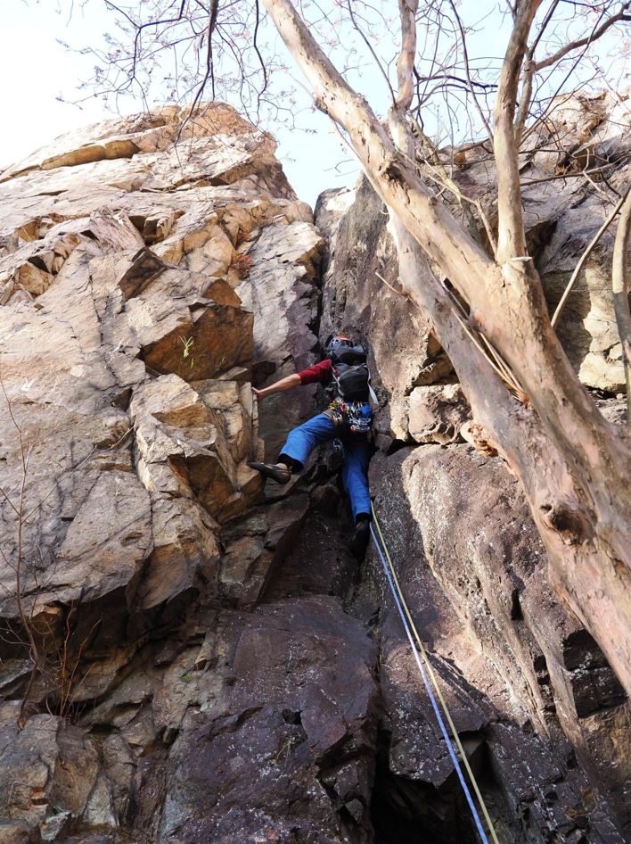

Pitch 2: Continue straight up the corner crack
system above (offwidth in places) to the bottom of a steep flared offwidth.
Climb this and exit leftwards to a bolted belay. (3m 5.8)


Pitch 3: Climb the bulge on climber’s right, then
continue up the run-out edge leftwards, being very careful not to dislodge any
loose rocks. (50m 5.6)

Pitch 4: There are three parallel cracks systems
that all go at a similar grade. Take your pick and climb the steep but featured
wall above to a bolted belay. (30m 5.6)


Pitch 5: Climb the crack system trending up and
rightwards, then climb a slab to your left to a bolted belay. (50m 5.5)

Pitch 6: This pitch can be avoided by heading up the loose gully round the back. But if you want to take it on, climb the line of weakness up the vertical face of the Fist rock (Kobushi-iwa, 拳岩) which constitutes the summit of the central wall. There are few options for protection, and the exposure here is massive, but there are enough holds to get through it. The final overhang is exhilarating! (20m 5.8)


Descent:
From the top of the Gendarme you could continue scrambling
up the ridge behind to gain the main summit ridge of Nakakura-yama, and then
descend the long hiking trail from there back down.
Alternatively, just descend the Gendarme back to the
road you walked in on. To do this, head down on your right and follow a steep
and loose trail that weaves its way down through several gullies, with in-situ
ropes in a few places. Be careful with loose rock and scree, and consider rappelling
the sections with fixed ropes unless you are happy with the condition of those
ropes.


It should take around 30 minutes to reach the bottom
of the Gendarme, and then you just need to descend the hiking trail back to the
dam and the road, and then a walk back to the carpark.
Overall:
An exciting direct route up the centre of the Matsuki-sawa
Gendarme, in an area that blends both industrial history and natural beauty.
Bring 50m double ropes, a full set of nuts and cams, and around 12 quickdraws.
For more route descriptions, topos and general info on Japan's fantastic climbing, pick up your copies of the Climb Japan books on Amazon!

No comments:
Post a Comment